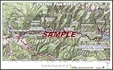
- USGS National Geographic Topographical Maps
- Extremely detail, full color, shaded relief
- Legal size, laminated (waterproof)
- Very attractive, printed on tan parchment paper
- Details hot fishing locations, camping areas, boat put ins, hiking trails
Product Description
This is a detailed river guidebook for the famous tailwater fishery of the Frying Pan River in Central, Colorado. This guidebook is 6 legal-size (8.5″ x 14″), laminated, custom USGS, National Geographic topographic maps covering 10 mile sections of the Frying Pan River from it’s headwaters above Ruedi Reservoir to its confluence with the Roaring Fork River in Basalt, Colorado. Each map has a detailed narrative on the back that covers all public fishing access, boat … More >>
Frying Pan River Fishing Guidebook – Colorado
If you enjoyed this post, make sure you subscribe to my RSS feed!